Results of H2020 STORM Project in the Assessment of Damage to Cultural Heritage Buildings Following Seismic Events
The CNVVF has started experimenting with the use of laser scanner systems in the quick assessment of the stability of buildings by inserting, from the first moment, the flow of 3D images acquired in an emergency within a technological platform designed to allow sharing information and data with the other institutions involved in the assessments.
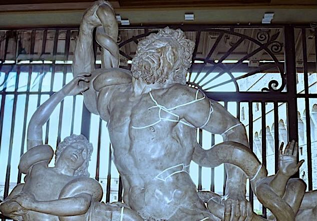
It is worldwide known that the restoration of Notre Dame, severely damaged by a massive fire on 15 April 2019 will be supported by the wealth of data acquired few years before, in order to release the Ubisoft’s ‘Assassin’s Creed: Unity. This fortuitous case highlights an aspect that could become critical in the conservation of works of art, starting with buildings and monuments. The meticulous scanning, with a precision of not less than 5 mm, has made evident to the public an aspect already known to the experts: the reconstruction or restoration of assets damaged by time, war events and malicious or negligent actions they can be potentially helped if the goods themselves have been documented with laser scanning or photogrammetry techniques.
The same consideration can be applied to the emergency assessments on the damage and on the level of risk of collapse that, for example after an earthquake, the first responders must perform to allow the rescue of people, the recovery of assets and the safety of non-collapsed structures.
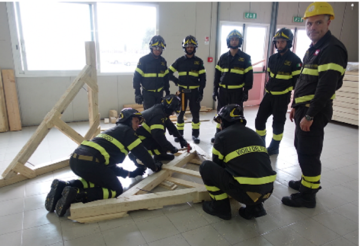
In particular, assessing the degree of damage that an earthquake has induced in a building is a duty of rescue services. In many severe earthquake events, the area hit should be assessed only by first responders team trained at working where buildings can collapse. Normally, the teams deployed to operate in such scenarios belongs to the USAR personnel, which are trained to operate where location, extrication, and initial medical stabilization of victims trapped in an urban area is needed. No wonder, therefore, if in a country particularly full of buildings of historical value such as Italy and, at the same time, subject to seismic risk, the national technical rescue service (CNVVF) has invested resources over time in the study of operating procedures and in the training of personnel who intervene on historic buildings damaged by earthquakes.
The experiences gained over the years on the occasion of the main earthquakes that have affected the Italian territory have made the CNVVF, Italian Fire and Rescue Services, in the field of emergency interventions on historic buildings, an excellence. In particular, the earthquakes that hit Italy in 2009 , 2012 and 2016-2017 have shown the ability of the CNVVF to operate in a coordinated way even on a large scale for the safety of damaged buildings, ensuring the presence of specialised personnel and the supply chain necessary to carry out the necessary measures.
The research project H2020 STORM ended in June 2019 and has dealt also with the assessment in an emergency of the stability of buildings damaged by seismic events , gave the opportunity to improve reliability and accuracy of the assessments through the use of laser scanner tools available on the market. Such improvement can be integrated into the procedures adopted by the CNVVF in the stability checks of buildings in emergency situations.
The CNVVF provides the emergency verification of the static safety of buildings in urgent technical assistance and calamities. This activity also concerns cultural heritage and was the subject of a research and development project funded by the European Commission in the Horizon 2020 program. The project STORM made it possible to verify, with a positive outcome, the possibility of using Lidar technologies to support safety assessments in emergency conditions.
Why Lidar technologies have been selected? The total stations and laser scanners, for their ease of installation and interrogation in real-time or processing and post-processing, can be used in different types of indoor and outdoor environments and, above all, they are not affected by the light conditions.
They allow the acquisition and storage of data or their post-processing to assess any structural changes in case of monitoring in buildings or to highlight possible landslide movements. Furthermore, the collected data can be processed in CAD, printed and shared.
As for the invasiveness of the method, the survey with the total station and the laser scanner has completely favourable characteristics, as the instrument is characterized by non-contact operating modes. The measurement of the topographic points can be performed with prisms, positioned at the target points or by attaching reflective targets on the artefact. In the case of total stations without reflector, the points are measured without any contact and in this case, the measurements are completely non- invasive.
In any case, to adopt photogrammetry and/or laser scanning in the rescue operating procedures the following questions have to be considered:
- Can the output be used to detect movements or the overall degradation of buildings and individual structural elements monitored? is it possible to detect the impact of the main dangers or threats by comparing the time- lapse models?
- Is there a significant difference between the two methods of cost survey and results?
- How sensitive are the devices to handling and transport?
- Are the costs in question accessible within a typical budget for the adoption of a heritage project?
- Are the costs in question accessible within a typical budget for the adoption of a heritage project?
- Are data acquisition and model processing time appropriate for the different operational phases of crisis management?
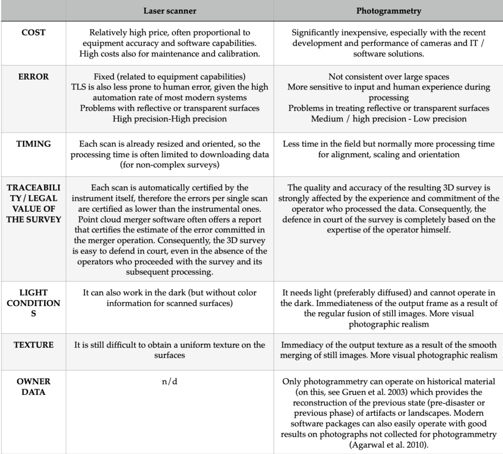
Since laser scanning and digital photogrammetry produce quite similar results in terms of the final output, it is appropriate to illustrate the most evident differences according to the scheme indicated in the table below, taken from the CNVVF paper published within the project STORM.
Over the years, the CNVVF has achieved the full internal data exchange capability, which also allows full interoperability with other structures operating in the emergency. This functionality is based on the CAP (Common Alerting Protocol), adopted since 2008 to facilitate the exchange of data with all the entities involved in an emergency.
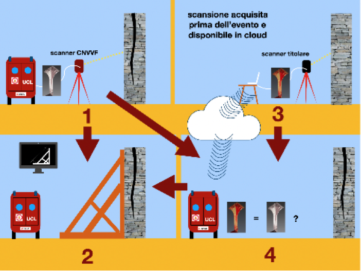
In the wake of the principle of interoperability, in the STORM project, the CNVVF promoted a further strategic hypothesis, that led to carrying out the experimentation on the use of the laser scanners and the capability of use 3D scans made available in the cloud.
Applied in a large-scale emergency, the project would allow the CNVVF to compare the scans acquired on the spot with those made before the incidental event, to assess the differential displacements suffered by significant points from the structures (displacements acquired in the order of the size of millimetres, or in the worst conditions, of centimetres).
This hypothesis, already feasible as the technologies are validated and available on the market at affordable costs, presupposes an agreement between the interested parties to define the acquisition and exchange standards of the 3D point clouds, including the documentation necessary to determine the accuracy of 3D images.
In this context, the CNVVF has started experimenting with the use of laser scanner systems in the quick assessment of the stability of buildings by inserting, from the first moment, the flow of 3D images acquired in an emergency within a technological platform designed to allow sharing information and data with the other institutions involved in the assessments. The demonstration of the effective operational capacity of this project was demonstrated in the final STORM project exercise, carried out at the Museum of the Baths of Diocletian in Rome. In this context, the scans were also used as a basis for designing the temporary works of the structures for which post-earthquake damage has been simulated.
The diffusion of cost-effective laser scanning tools offers the possibility of making the survey activity in emergency conditions more consistent with the needs of protecting operators. More over, it improves the efficiency of the recovery process of historical and artistic value artefacts and the reduction of the structural problems of historic buildings damaged by sudden events. The use of innovative technologies could be usefully exploited to cope with complex situations that the faces CNVVF to overcome seismic emergencies. Aftershocks of intensity similar to the main shock and the migration of the epicentres show the need of repeated monitoring of the geometric configuration of the buildings and the related state of damage. Moreover, obtaining such data would make them more objective and shareable with other operators of the emergency system.
The H2020 STORM project has made it possible to successfully evaluate the hypothesis of introducing the use of laser scanners and total stations for emergency survey in the operating procedures of the CNVVF. An hypothesis of development and further improvement of the results offered by this approach involves the use by rescuers of scans acquired by the owners of historic buildings for the needs of conservation and maintenance. For this purpose, the definition of the operating procedures and the creation of an IT infrastructure are issues of which the STORM project has demonstrated the technical practicability.
One more aspect to be considered deals with the significant benefits to the entire safety management process (both during ordinary rescue activities and in post-seismic emergency conditions) that the digitalisation of the assessment process can bring. A system that allows rescuers to draw 3D models from a database accessible in the cloud and compare them with the on site scans, could be implemented. The STORM project has taken care of the preparation of the repository platform of the scans carried out in ordinary conditions. The CNVVF staff has been able to access to such system, since it has been designed and built to be interoperable with the applications in use at the CNVVF. The interoperability of the systems, in turn, was also allowed by the use of the CAP protocol.
In the situation described, a further improvement could be generated by the gradual adoption the information model of buildings (BIM, building information modelling) to historical buildings (HBIM, historical BIM). This process is mandatory in Italy, according to the decree 01/12/2017 of the Ministry of Infrastructure and Transport and has to be applied for the execution of all public building interventions starting from 2025. In the proposal of the CNVVF paper, if a proper procedure and specific requirements are agreed among the stakeholders (property and managers of the buildings, Cultural Heritage protection agencies and emergency services), it could reveal to be extremely useful in the emergency survey for the data it contained.
Read the paper